
2013 Kootenay, Yoho, and Mt Revelstoke National Parks
September 13 2013

At Marble Canyon
Kootenay National Park covers almost 350,000 acres. Kootenay offers a variety of landscapes and is a good place to go in the Canadian Rockies to get off the beaten track. Situated on the west side of the Continental Divide, Kootenay National Park extends across the valleys of the Vermilion and Kootenay Rivers.
Marble Canyon is 2.5 miles south of the trail-head for Boom Lake, on the other side of Boom Mountain, but it requires crossing the Continental Divide into British Columbia. The hike to the canyon is very short, just under 2 km, but the visual impact is amazing. From the parking area the trail takes a short dip down to the junction of Vermilion River with Tokumm Creek. The trail then climbs back and forth across the canyon on 7 rustic bridges. At the far end of the canyon is a 69 ft waterfall.
Numa Falls is one of the roadside attractions along Highway 93 that runs through Kootenay National Park. Just a short stroll takes you to a picturesque waterfall created along the Vermillion River.
September 21 2013

Hwy 1 into Revelstoke
Today, we travelled west on the Trans Canada Highway over Rogers Pass. We stopped at the highest point, Rogers Pass Discovery Center where there are interpretive trails and self guiding tours.
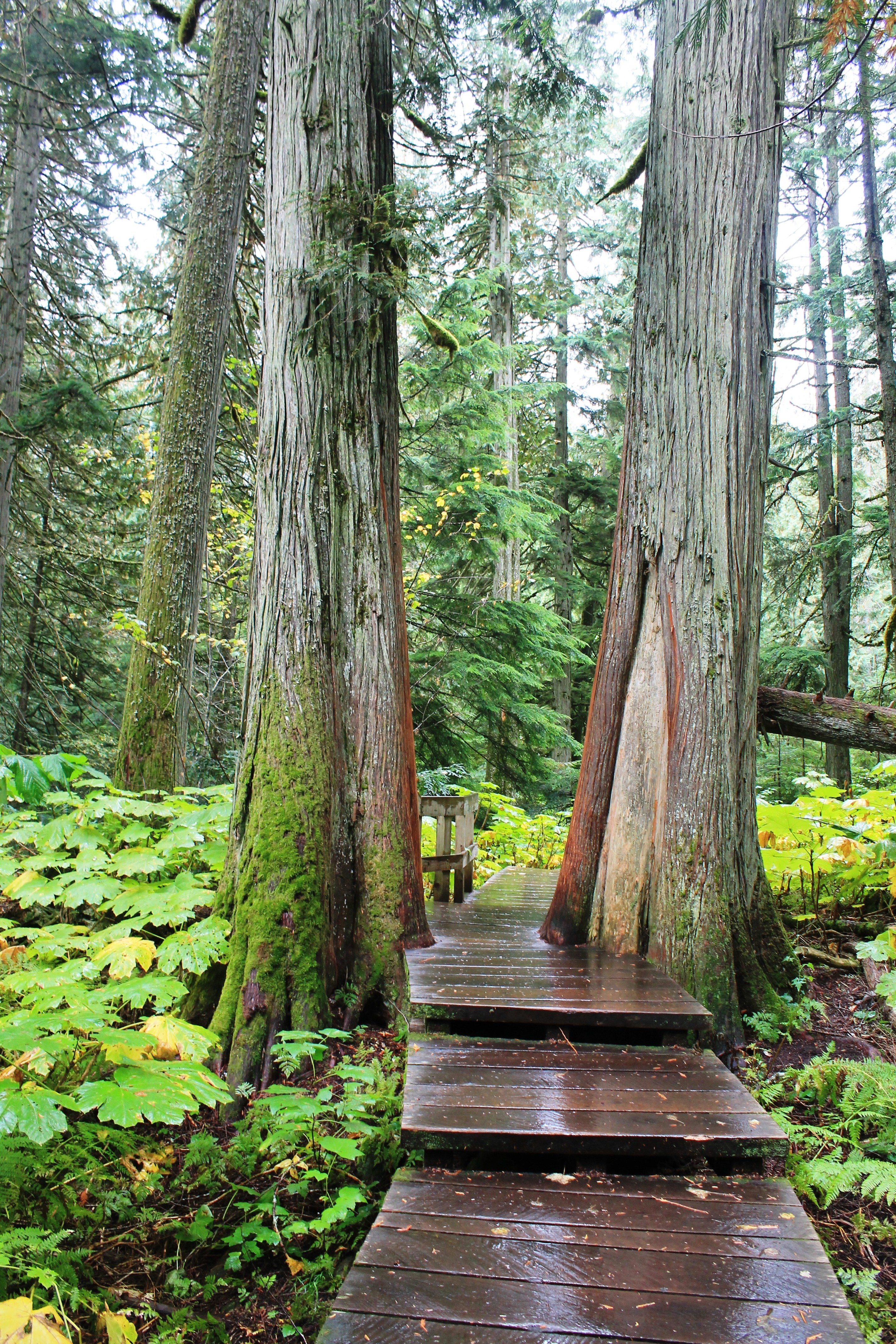
Giant Cedars Boardwalk
Rogers Pass is located in Canada’s Glacier National Park and provided the historic western route for the Canadian Pacific Railway. At the Rogers Pass Discovery Center, you can learn about the railroaders who carved the first path through this wilderness.
Our next destination was Mount Revelstoke National Park. We stopped at the Giant Cedars Picnic area and took a stroll on the Giant Cedars Boardwalk trail. A half kilometre boardwalk takes you into the heart of the park’s old-growth cedar forest. The cedars stood among the unique wetland plants.
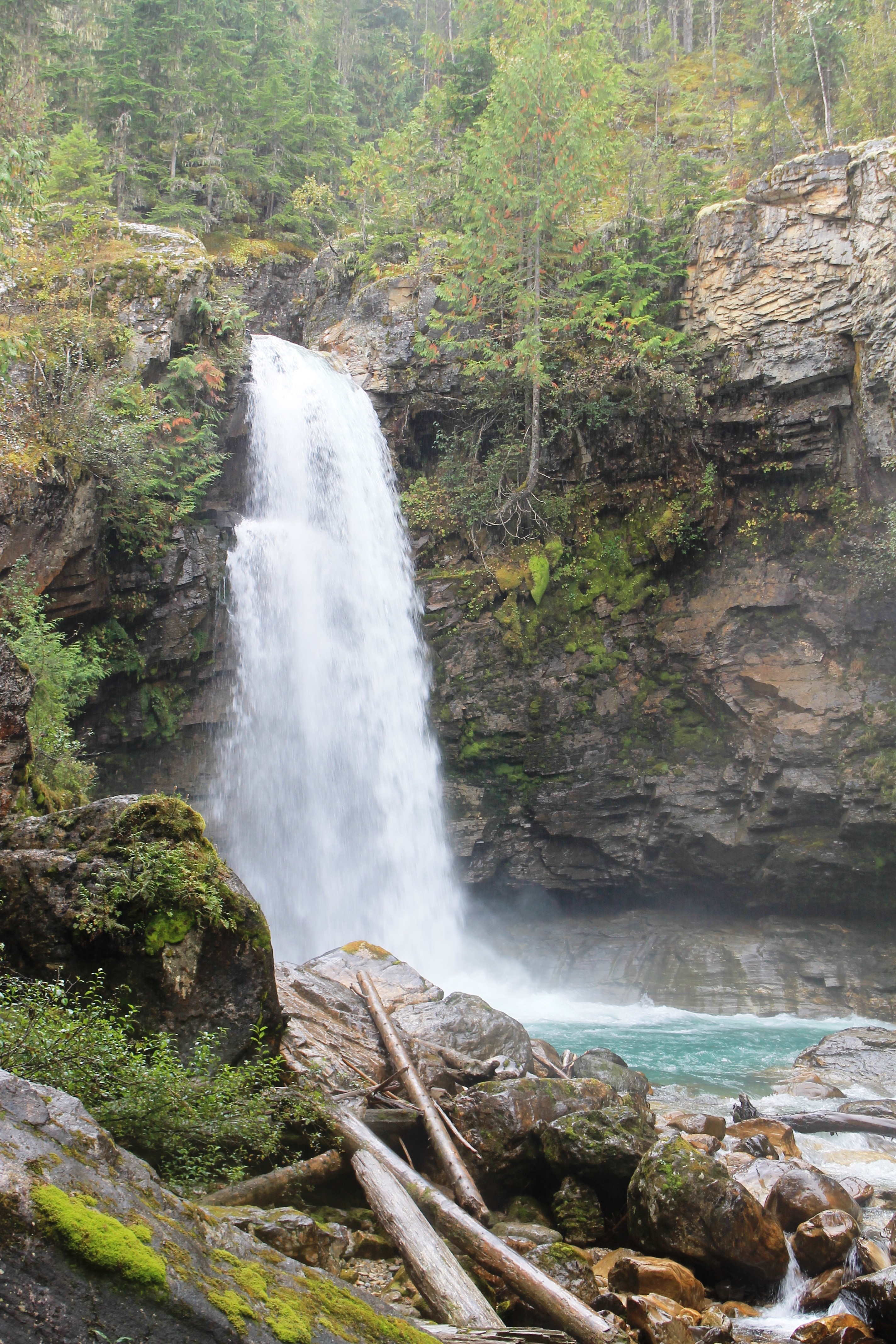
Sutherland Falls
Continuing west, we arrived in Revelstoke and turned south on Rt 23 to Blanket Creek Provincial Park.
This Provincial Park encompasses a farming area known as the old “Domke homestead” from the 1940’s. We were warned about bears being here in the fall, but we made a lot of noise and they stayed away from us.
We found an easy stroll to scenic Sutherland Falls where we took in the sight with no other tourists around. 🙂
September 22 2013
Yoho National Park sits on the western side of the Continental Divide, bordering Banff National Park. The name Yoho is a Cree expression of awe and wonder and fits this diverse landscape. I was kinda stunned by the massive highways being constructed on the west side of Yoho. This is a major ongoing highway project, so be aware.

Emerald Lake
Emerald Lake in Yoho is a fantastic place to see wildlife, as animals are drawn to the important water source. When you walk in this great landscape you are visiting the home of the moose, grizzly bear, elk, and cougar. 🙂 We were on the lookout for bald eagles, moose, ospreys and any other moving creature. The hike around Emerald Lake takes about an hour, and is one of the least strenuous but most rewarding in the park. Another short hike (with rocky scramble at end) takes you to Hamilton Falls.

Wapta Falls
Wapta Falls can be found near the west end gate of Yoho National Park on the Kicking Horse River. The waterfall is accessed relatively easily via a 30 minute hike. Well worth the effort, this hike is suitable for the whole family with the reward of an enjoyable outing to see one of Yoho’s largest waterfalls backdropped by the jagged peaks of the Ottertail Range.
Natural Bridge is an impressive natural rock formation that spans the flow of the Kicking Horse River west of Field, BC. The Natural Bridge lookout presents visitors with the opportunity to view the formation from a variety of different vantage points, with interpretive displays. The bridge can easily be reached by car just 3km from Field on Emerald Lake Road.
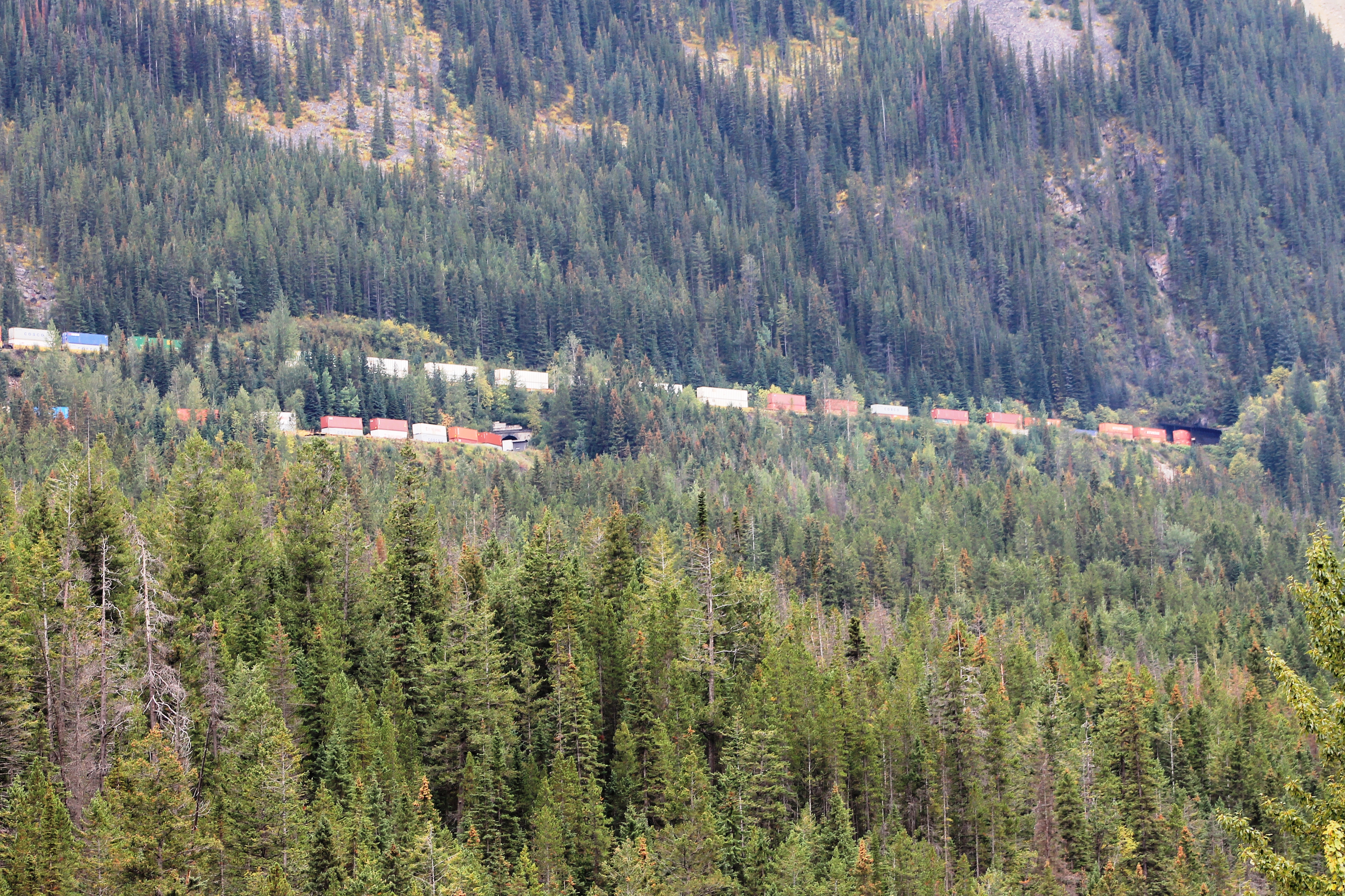
Spiral Tunnel
At the Spiral Tunnels viewpoint, we were lucky enough to see the Canadian freight trains pass through the tunnels. There is a single track but it appears to be more than one train as it winds through the spiral and goes through the tunnel. (Of course, there is only one train at a time!) The Upper Spiral Tunnel in Cathedral Mountain can be seen from the pull-off 2.3 km up the Yoho Valley Road.
Interpretive panels provide the explanation but you need luck and patience with the timing. The Spiral Tunnel viewpoints offer an opportunity to see this unique phenomena.

Takakkaw Falls
Nothing captures the awe and wonder of Yoho National Park like the tremendous thunder of Takakkaw Falls. ♥ Plunging from above at a height of 1246 ft with a 833 ft freefall, Canada’s second highest waterfall leaves every visitor amazed.
It is situated just west of the continental divide and is fed by snow and ice melt that originate in Daly Glacier in the Rocky Mountains. The falls are visible along the short trail to a bridge where there are wonderful photo ops. Walking further takes you to the base of beautiful glacier fed Takakkaw Falls.
One felt that the mountains are not completed. The builders are still at work.”
— J.E.H. Macdonald

Leave a comment